Showing posts with label Missouri River. Show all posts

Sunday, February 13, 2022

Jar of Goodness 2.13.22: Adrian’s Island Jefferson City

. . . The weekly virtual “gratitude jar.”

This week, I’m expressing thanks for Jefferson City’s new public park on Adrian’s Island.

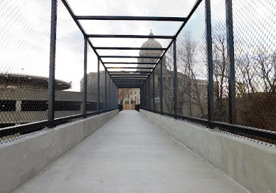
The park is named Deborah Cooper Park, and the soaring pedestrian bridge linking it to the Missouri State Capitol grounds, and over the Union Pacific tracks, is named the Missouri Bicentennial Bridge. And Adrian’s Island isn’t technically an island, since it’s broadly and clearly connected to land. But Memphis has its “Mud Island,” which is about the same thing.

(Oh, and all you naysayers, who've been against the development of this new park? You know, because it's expensive, and because it'll flood? . . . Well you can kindly stay off it. Go someplace else.)

I’m not going to repeat a bunch of stuff that’s already been covered in the papers and elsewhere.

But I will share some pictures I took of the place on a recent visit. If you haven’t been to see it yet, you really should go. Though until it gets genuinely warm, make sure you dress extra warmly. The breezes can be kind of stiff off the river.

And you do get some nice views of the river. And the Highway 50/63 bridge, too.

The views from the soaring bridge over the tracks are pretty nifty, too. Look for waterfowl and gulls and bald eagles!

At this point, landscaping is nonexistent. They had time before winter to plant several swamp white oaks—yes! Beautiful, poetic, hardy native hardwood! And they applied grass seed to the dirt surfaces, and installed some anti-erosion fencing, but that’s about all. By now, after rains and snow and meltwater, erosion is happening anyway, and they’re going to have their hands full reseeding. Hopefully they won’t make it all be just . . . lawngrass. (Aren't there enough places for people to throw balls around in this city?) But we’ll see.

Okay, and you get good views of the dredging barges and the sand plant across the river, and whatever they’re doing.

I appreciate being able to finally see the railroad cut in the bluff on the north side of the capitol. When you stand at the top of that bluff, by the Signing of the Louisiana Purchase statue, you see the river beyond, and you can kind of see a few of the siding tracks, but apart from the brush and weeds, you can’t get a good sense of the actual bluff and the extent of the tracks. It’s neat to see that perspective.

AND, if you’re into trains, the overpass offers great views of those, too! But that’s another post.

Monday, April 11, 2011

Touching the Missouri River

There were several speakers at the ribbon-cutting Friday, but the one who made the most hay from his time before the microphone was Mayor John Landwehr, who reminded the audience of the importance of the river to Jefferson City.


Using Woody Guthrie’s “This land is your land, this land is my land” as a theme, he spoke of our common interest in the Missouri River and asserted that by reaching out and “touching” the river, Jeff City will join Hermann, Washington, Little Rock, Memphis, Wichita, and Ottumwa as cities that “learned how to touch their rivers.”

Coastal cities have the ocean; mountain cities have their peaks; and we have our river: We can use its enduring scenic and historic nature as a way to gain tourism revenue and a stronger sense of identity. Landwehr suggested that, as we cross the new pedestrian/bicycle bridge, we think of our connections to the river.

And he spoke of the importance of the Adrian Island project in beautifying and vitalizing the city.

If you’ve ever been to Mud Island in Memphis, you have some idea of what Adrian Island—now just a huge sandbar thick with weedy bottomland trees—could become, albeit on a much smaller scale. Or you could look at Hermann, New Haven, or Washington’s waterfront parks, which are incredibly pleasant places to have a picnic—I know, because I have picnicked at each of them, on food purchased at restaurants in those towns.

Here is a view of Jeff City taken from the new bicycle/pedestrian path attached to the Missouri River Bridge. I've circled Adrian Island for your reference.


The idea of building a tunnel under the railroad tracks to provide access to the island is controversial for a number of reasons (that usually come down to money), but the idea of developing the area as some kind of city park is one that’s long, long overdue. We’ve got a historic and attractive downtown, and a spectacular Capitol, but no way to “enjoy” a view of the river except for a simple MDC boat ramp on the opposite bank.

Surely there’s a way to work with the railroad to provide access to that land without endangering pedestrians or infringing on the trains’ ability to come and go.

Indeed, I find the coming-and-going of trains almost as fun to watch as the river! How about an adjoining train or transportation museum? Perhaps some of this could even benefit the railroad.

Little ol’ Cooper’s Landing, up at Easley, offers better ways to enjoy the river than the capital city.

And although I’m beginning to see that many Jefferson Citians have a grudge against Columbia, where “anything goes,” I’m also concluding that a lot of that is just jealousy. If Columbia were located right on the Missouri, you know there’d be a lovely waterfront park, lots of great restaurants nearby, shopping, and so on. I mean, look what they did with the Flat Branch, which, when I was a kid, was nothing but a trashy ol’ drainage ditch.

Columbia's longtime, recently retired mayor, Darwin Hindman, was at the ribbon-cutting ceremony, and it was great to see him and outgoing Jefferson City mayor Landwehr chatting together as they began to ascend the new bicycle/pedestrian ramp. Both of these leaders understand the importance of quality of life in a town. I'm afraid I'm going to miss both of them quite a bit. I hope they stay involved.


Now, this is just my two cents. I’m not an economist or a developer, but I can speak as a resident and consumer, and I just know there’s a way for Jeff City to use its proximity to the river to our advantage. My fear is that our city is too pessimistic, reactionary, and inflexible to move forward, and that we will be the last river town in the United States to do so.

. . . But my hope is that that isn't the case.

Sunday, April 10, 2011

The Pedestrian Bridge Is Open!

Friday morning was the ribbon-cutting ceremony and the official first crossing of the new pedestrian lane on the Missouri River Bridge!


I told you about the groundbreaking ceremony for this project last May. Click here for some scary "before" photos!

The new section is attached by enormous brackets to the eastern edge of the northbound bridge.


This nice, wide path is a huge improvement on how it used to be, when walkers and bicyclists had only a few feet of thin air between themselves and the 50,000 cars and trucks that blast over the river each day.


Not to mention that bicyclists attempting to ride south to reach Jeff City were forced to ride on the left, against traffic, which is kind of suicidal, plus it's ingrained into us all as illegal. Most Katy Trail bicyclists, I suspect, simply opted to stop at Hartsburg instead, with an attitude about Jeff having "nothing worth risking your life to see."

To access the bridge from the south (Jefferson City), park near the intersection of West Main and Clay streets—that’s where the pathway begins, behind bright yellow posts.


Round the curve, and soon you'll be on the bridge.


There is a special section with higher fences over the train tracks; I think it's to prevent the slower among us from throwing objects down on the rails.


The path gives you excellent views of Jefferson City and the state capitol. There are two places over the river where the path widens, where you can pause to enjoy the view.


You can take great photographs from the bridge!


Then, once you’re over the river, a big ramp, shaped like a square spiral, leads you down comfortable grades to the river bottom, near the Noren River Access. From there, a short ride leads to the “North Jefferson City” access point of Katy Trail State Park.


The Katy Trail, I should mention, is the longest rails-to-trails pathway in the United States; at the present, it extends from St. Charles in the east to the city of Clinton in the west; much of it includes incredibly scenic stretches through Missouri’s wine country and between tall limestone cliffs on one side and the beautiful Missouri River on the other.

Although initially it was controversial, especially among landowners who believed the trail would deliver riffraff and trash onto their rural properties, the Katy Trail has proved enormously helpful to many small communities that had seen nothing but “bust” since the decline of the railroads. Now, the Katy Trail brings cyclists (such as me), hikers, big-city residents with disposable income, and family day-trippers to these small towns, and they’re interested in dining, shopping, spending the night at B&Bs, and getting a taste of the “local color.”

Towns such as Boonville, Rocheport, Hartsburg, Hermann, and Sedalia are called “Katy Trail Towns,” and now that Jeff City is officially connected, it becomes a Katy Trail Town, too!

I can’t wait until my ankle’s all better, so I can start riding my bike across! (That ramp looks like a lot of fun!)


One more thing: Although the local and state officials who spoke at the ceremony had lots of thanking to do--and I won't repeat it here, for there were many individuals and businesses who donated to this project (look for their names on pavers and a plaque at the south end of the bridge)--I want to express my appreciation, respect, and admiration for the workers who risked life and limb while constructing the pedestrian bridge. Here are some of them.


Folks, they were out there on the edge of the bridge in the freezing cold, with cars whooshing right past them at ninety miles per hour (in a sixty mph zone), and working high over the river; there were dozens of ways to die out there. And it was a record-snowfall winter, yet they finished on time and on budget. Great work, fellows! I will think of you each time I use the bridge!

Thanks, Sue, for taking such awesome pictures!

Wednesday, May 12, 2010

Missouri River Pedestrian Bridge at Jefferson City


This morning was the groundbreaking ceremony for the long-awaited pedestrian addition to the Missouri River Bridge here at Jefferson City. I’m not an official journalist, I’m just a blogger, and an amateur one at that—but I’m thrilled that this project is moving forward!


Indeed, it’s a step forward on many accounts. It advances tourism in Jefferson City. It advances the connection of the Katy Trail State Park with neighboring communities. It advances safety for bicyclists and pedestrians as well as for the over 50,000 vehicle drivers that cross the river here each day.

(Nifty shovel, huh?)


In order to appreciate what we’re getting, you have to know what we have now. Right now, there are two bridges crossing the river—the one on the west is for southbound traffic and the one on the east is for northbound. When they built the second of these two bridges (the northbound one), back in 1991, they didn’t take possible pedestrian or bicycle traffic into account.

Meanwhile, also twenty years ago, the Katy Trail State Park was launched. Indeed, they’re celebrating this rails-to-trails park’s twentieth anniversary this month! It follows the old MKT railroad line from St. Charles clear to Clinton, Missouri.

It passes by Jefferson City right across the river at a point they call “North Jefferson”—but which many of us locals still think of as “Cedar City.” Cedar City was destroyed by the Great Flood of 1993.

Anyway, Jeff City has annexed the former town, but there’s really not much there beside the MFA, a golf range, some big soccer fields, and the Katy Trail access point.

So a problem arose: Even though the city built a nice bike trail connecting the cross-state Katy Trail to a point nearer to the Missouri River Bridge, bicyclists had hell to go through before getting across the river to Jeff City proper.


And that’s bad for tourism! And it’s dangerous, any way you slice it. The temporary solution has been to add a “bike lane” to the northbound (wider) bridge. But . . . that lane must function for bicyclists traveling both directions.


Now, if you’re a grown-up, responsible bicyclist, every fiber of your being should rebel against the thought of riding on the left side of the road, against traffic. But that is what you’re “supposed” to do if you are heading south, toward town. Argh!


And God forbid you should have to pass another bicyclist going the opposite way! —But of course, that rarely happens, since most bicyclists don’t want to attempt this ugly crossing.


Seriously—the traffic on the bridge is posted at 60 mph—which you know means many people are traveling at 70 mph. Including huge trucks.


You can’t tell from a car, but you can tell when you’re walking: Those big trucks make the bridge rumble and shake. They pass you in a whirlwind, stirring up grit and litter, creating a suction that threatens to pull you away from the shoulder. No joke.


So they finally did it—all these agencies, governments, and organizations put their heads together, and the work is beginning next week. (They would have begun this week, they said, but for all the rain.) A local company from Fulton, OCCI, Inc., won the bid.

The project is going to cost $6.7 million—the money’s coming from MoDOT, the City of Jefferson, the DNR, and the Missouri State Parks Foundation. That last is a private, nonprofit organization formed to raise money for Missouri State Parks. There was a 20 percent local match.

The Missouri Department of Transportation is naturally in charge of this project, as it pertains to Missouri Highways 54 and 63, which merge at this point to get across the river.

But, as Mayor Landwehr pointed out in his brief remarks, this has been a three-times complex project—complex engineering, complex funding issues, and complex in terms of policy, the drawing together of the governments of Callaway and Cole counties, the City of Jefferson, plus the state agencies for highways and state parks.

He also noted the good the pedestrian access will do for Jefferson City, “connecting the dots” of the Katy Trail with the State Capitol (which is a huge tourist attraction), the 12.5-mile Jefferson City Greenway system, and, one day, a development on Adrian’s Island making it friendly for public recreation.

It also makes it much easier for residents of Jefferson City to ride directly to the trail, instead of having to load their bikes into a vehicle and drive there. And that, my friends, will make Jefferson City—particularly the old-town portions near to the bridge—into a more desirable place to live.

And you know the Jefferson City CVB is thrilled about this project—there are thousands of riders on the Katy Trail, and it would be grand to have them spend the night in Jeff, eat at one of our fine restaurants, do a little shopping . . . !

So the plan is to attach an eight-foot-wide pathway against the east edge of the easternmost (northbound) bridge—which provides enough room for a couple of bikes to pass, as well as pleasant views of the State Capitol and the river. There will be a couple of places where you can stop to take in the sight.


Here is a view of the east side of the bridge, where it is going to be attached:


It must have been fun for them to figure out how to handle the trail on the north side of the river, since the bikes would have to cross the highway somehow. To accomplish this, they’re going to build a multi-staged ramp so that trail riders can get from bridge level down to the ground, then ride under the bridges to the nearby (and scenic) Carl R. Noren river access. (Which is managed by the Missouri Department of Conservation—see, I told you this is a complicated project!)

I took a picture of one of the artist-renditions of what the ramp will look like. I'm sure you can see this better on the MoDOT Web site:


From the river access (boat ramp), the trail will lead to the existing Katy Trail “North Jefferson” access point.

I don’t know about you, but as a native Central Missourian, I treasure the Missouri River, and from a young age, I have always assumed that one of the main reasons for bridges is for you to get a good look at all that water rushing below, and the landscape around. It has seemed unnatural that Jefferson City hasn’t done much to monopolize on its several potentially fabulous river views.


Mayor Landwehr pointed out, I think correctly, that the Missouri River is our own “big nature.” “We don’t have Rocky Mountains or an ocean here. But we have the Missouri.” And yes, it is unique.


As I stood there listening to the speakers at this morning’s groundbreaking, my eyes were incessantly drawn to the river going by in the landscape beyond them. It is hypnotic, it is inevitable, and it is somehow gentle. More people ought to look at rivers, and the pedestrian bridge is one step in the right direction.


They say it will be complete a year from now!


Meanwhile, they cautioned, lanes will be narrowed, traffic will be forced to slow down, and you won’t be able to get on the bridge from Main Street. I say: No problemo! Bring on the bike path!


Thursday, January 21, 2010

Thinking Place


You have a place like this, I’ll bet. It’s somewhere you go to be alone, to relax, to clear your mind, and to think. It has to be someplace different from your daily surroundings—different enough to jar you out of your stale mind-set.

It has to be someplace fairly convenient to get to.

For me, one requirement is a view. Over the years, my thinking places have been mountaintops, beaches, hillsides, high bluffs, even the top floor of a big library.


Since I moved to Jefferson City, my habit has been to linger at the Missouri River overlook on the north side of the State Capitol. That’s the place with the exuberant Fountain of the Centaurs, by Adolph A. Weinman, and the large bas relief sculpture The Signing of the Louisiana Purchase Treaty by Karl Bitter, which was created for the 1904 St. Louis World’s Fair.

These are remarkable artworks, but for me the real attraction at this site is to the north: The busy train tracks just below the bluff, skirting the river; and the Missouri River Bridge bearing traffic from highways 63 and 54, merged here to cross the Big Muddy.


On the bank across from here is a sand company, with its dredging barges often docked; vehicles crawl back and forth unloading, shifting the sand into mounds; they beep when they back up. Farther across the river is the local airport, too.

And of course, the biggest attraction is the river itself, constantly sliding from left to right, on its way down to St. Louis. It is hypnotic, calming, relentless.

So as I stand there I sometimes make a game for myself and count, like a child, the different forms of transportation: car, truck, boat, train, plane . . . and grow more serious as I think about how important this river and these conveyances have been to the development of this city—and all cities.

It is easy for me to walk up to the Capitol from where I live. The Capitol is also an easy detour before I come home from most anywhere. Day or night, even in the rain or snow; it helps settle my mood before I step through our door.

But most often, I go there to just stare at the river and get a grip on my thoughts, time . . . my life.


Monday, November 2, 2009

Clark’s Hill/Norton State Historic Site


What did you do on Halloween? It couldn’t have been any more fun than we had visiting a “new” place for us, east of Jefferson City. Clark’s Hill is a 13-acre property that was acquired by the Missouri Department of Natural Resources in 2002. Since it’s kinda new, we don’t feel too sheepish about our unfamiliarity with it.

The site is open from eight in the morning until a half hour after sunset. If you can get to Osage City, you can find the Historic Site by simply following signs. (Okay: Osage City is east of Jeff on Highway 50; turn north at Route J. Keep a-goin’. You can’t miss it.)


The site is called Clark’s Hill because this is the very hill that Captain William Clark clambered up in 1804 when the Corps of Discovery was ascending the Missouri. Lewis, Clark, and their crew camped at the base of this hill on June 1–3 of that year.

The “Norton” in the site’s name honors William and Carol Norton, who donated the site to the DNR in time for it to open in 2004, for the bicentennial of the Lewis and Clark Expedition. Pretty cool, huh? Thank you, Mr. and Mrs. Norton!

There’s a great deal to make this place interesting. William Clark wrote about the view from this hill, calling it a “delightful prospect.” And visitors to the site today can share his delight, using a well-constructed half-mile trail that ascends and leads along a ridge of the narrow piece of land dividing the Osage River from the Missouri, where the two rivers join. The trail ends at an observation deck that is basically where Clark stood.


Toward the end of the trail, you can see the Missouri on the left . . .


. . . and the Osage on the right.


There are several well-illustrated interpretive signs along the trail that talk about the history of the expedition, the natural history of the area, the Woodland peoples who inhabited the area for many centuries, and the story of the river and its changing character and course.


There are also a good number of benches along the route. If you are not much of a hiker, you will enjoy this trail, despite the occasional incline (you are ascending a hill). If you are a diehard hiker, you will still see enough cool views and interesting organisms to keep you delighted.


The Changing Confluence

Things have changed since Clark made his observations and measurements. Most notably, the river has been channelized, and the Osage’s confluence with the Missouri has moved about six miles downstream (but don’t worry, there’s still plenty to see from Clark’s observation site).

The peninsula of land used to end abruptly at the hilltop where Clark stood (and where a nice observation deck stands now), but now the peninsula is greatly extended by flat land—really a series of connected islands or gravel bars—so that the Osage now joins the Missouri at the town of Bonnots Mill. Much of the flat peninsula is now the Smoky Waters Conservation Area (administrated by the Missouri Department of Conservation).

Look at it on Google Maps, and then, for comparison, see this nifty Web site to inspect maps that reconstruct the Missouri as it was when Lewis and Clark explored it.

The Missouri has shifted to the north, and at Bonnots Mill the Osage now flows in the Missouri’s old channel. The character of the Osage changed upon the completion of Bagnell Dam in 1931. After damming, the river began to deposit more sands, gravel, and other coarse materials at the confluence, and that’s what created that flat peninsula beyond the hill where Clark stood.


Also, about the 1930s was when the Missouri got seriously channelized for navigation, and a main levee was constructed along the Missouri, on the northern perimeter of Clark’s Hill. You can see it from the trail, below a steep slope. The trail offers many nice views of the Missouri and the croplands, even Highway 94 and the Katy Trail, on the other side.


Natural History

We saw a three-toed box turtle digging into the leaf litter.


We saw some lovely clusters of puffball mushrooms, which always make us feel happy, like clapping laughing babies.


We even saw a pretty pink stinkhorn mushroom, right along the trail.


There were also woodpeckers and herons, even during the “birdless” midafternoon hours, and butterflies, woolly bears, a spring peeper, and many graceful, wolflike running spiders. We weren’t “looking” for this stuff; it was just there.

And especially near the trailhead, there were lots of Osage oranges, which always cheer me with their utter weirdness. Coming upon a patch of ground littered with these grapefruit-sized chartreuse “brains,” I always feel like I’ve landed on a strange new planet. I’ll never get tired of them. I always stoop to pick one up and marvel at its strangeness.


Here, too, on the north-facing side of Clark’s Hill, is one of only six places in the state where amethyst shooting star (Dodecatheon amethystinum) is known to grow. It’s a remnant of the glacial ages and is extraordinarily rare in Missouri. They’ll be blooming around April. (We’ll just have to go back to see them!)

Pawpaws—good ol’ “Missouri bananas”—are another notable plant of this area, for in September 1806, when the Corps of Discovery was making its return trip through here, Clark wrote that his men were running out of foodstuffs and were divvying up their “buiskits,” but were “compelled” yet “perfectly contented” to eat “poppows.” . . . Then some of the men complained of having trouble with their eyes and the skin on their faces. They blamed overexposure to the sun, but today we suspect it might actually have been a reaction to the rind resins of the many sweet pawpaws they were devouring.

One unfortunate thing about the ecology of the area is that the area is thick with invasive bush honeysuckle. Their still-green leaves and bright red berries surely do make them attractive and noticeable, but it doesn’t change the fact that this species gets way out of hand. It’s sad to see it in such abundance here, because it’s all over. Wonder how they can hope to control it, or get rid of it here? It’s gonna take a helluva lotta work. At the least, I hope they can keep it away from the amethyst shooting stars.


Human History

Clark noted two Indian mounds in his journal at this location, plus there are three more you can see. There are signs describing what is known of the people who buried their prominent citizens here, discussing their methods of burial, their civilization, their way of life. Very interesting. These graves are perhaps 1,400 years old—still overlooking the river named for the Wah-Zha-Zhe, and the river named for the Ouemessourita. A moment of silence . . .


Summary: You can bet we’ll be back. It’s a short drive from Jefferson City, so it’s easy to get to. If you haven’t seen this place, you really should check it out. There’s archaeology, natural history, American history, geology, hydrology, beautiful views . . . plenty of stuff to make you smile.