Showing posts with label bridges. Show all posts

Sunday, February 13, 2022

Jar of Goodness 2.13.22: Adrian’s Island Jefferson City

. . . The weekly virtual “gratitude jar.”

This week, I’m expressing thanks for Jefferson City’s new public park on Adrian’s Island.

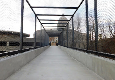
The park is named Deborah Cooper Park, and the soaring pedestrian bridge linking it to the Missouri State Capitol grounds, and over the Union Pacific tracks, is named the Missouri Bicentennial Bridge. And Adrian’s Island isn’t technically an island, since it’s broadly and clearly connected to land. But Memphis has its “Mud Island,” which is about the same thing.

(Oh, and all you naysayers, who've been against the development of this new park? You know, because it's expensive, and because it'll flood? . . . Well you can kindly stay off it. Go someplace else.)

I’m not going to repeat a bunch of stuff that’s already been covered in the papers and elsewhere.

But I will share some pictures I took of the place on a recent visit. If you haven’t been to see it yet, you really should go. Though until it gets genuinely warm, make sure you dress extra warmly. The breezes can be kind of stiff off the river.

And you do get some nice views of the river. And the Highway 50/63 bridge, too.

The views from the soaring bridge over the tracks are pretty nifty, too. Look for waterfowl and gulls and bald eagles!

At this point, landscaping is nonexistent. They had time before winter to plant several swamp white oaks—yes! Beautiful, poetic, hardy native hardwood! And they applied grass seed to the dirt surfaces, and installed some anti-erosion fencing, but that’s about all. By now, after rains and snow and meltwater, erosion is happening anyway, and they’re going to have their hands full reseeding. Hopefully they won’t make it all be just . . . lawngrass. (Aren't there enough places for people to throw balls around in this city?) But we’ll see.

Okay, and you get good views of the dredging barges and the sand plant across the river, and whatever they’re doing.

I appreciate being able to finally see the railroad cut in the bluff on the north side of the capitol. When you stand at the top of that bluff, by the Signing of the Louisiana Purchase statue, you see the river beyond, and you can kind of see a few of the siding tracks, but apart from the brush and weeds, you can’t get a good sense of the actual bluff and the extent of the tracks. It’s neat to see that perspective.

AND, if you’re into trains, the overpass offers great views of those, too! But that’s another post.

Thursday, May 19, 2011

Here’s What’s Up

I never know how to name or begin these “here is where I am right now” posts. But it’s been a little while since I’ve given you a general update, so I hope you’ll indulge me. If you’re not interested in my personal life, I understand. This is incredibly self-indulgent, I know.

The biggest news, for me, is that I saw the orthopedic surgeon and got X-rays on Monday, the ninth, and my fibula is now officially healed! There is a possibility that come October or November, the decision might be made to remove the plate and screws, depending on whether they’re bothering me or not. At this point, I have the sense that the screw fixing my fibula and tibia together is inhibiting the range of motion in my ankle (it’s impossible to squat, and hard to descend staircases without walking down them sideways).

Another reason they might want to take out the hardware is that there’s really not much “meat” between one’s lower fibula and that delicate ankle skin, and yes, when I reach down and touch my ankle, I can feel the plate and the lumpy little screw heads through my skin. At this point, that sore lumpiness, combined with the tenderness at the incision (it’s five inches long) (be glad I’m not posting pictures), makes it kind of impossible for me to sit “Indian style.” Not to mention that it’s just creepy. (But I can get over the “creepy” factor.)

Meanwhile, I’m not keen on having to meet the deductible again, which a second surgery could easily require.

There’s still swelling, aches, and pains that are residual from the injury itself, the surgery, and the few months of immobilization. “The body heals itself with collagen,” the doc said. And that ain’t helping the function of tendons, muscles, flexibility, and whatever. Or so I gather. I’ve got to “work out” that excess collagen and swelling-stuff, make my ankle lean and mean again.

Exercise and use should go far to restoring normalcy, the doc says, and he prescribed a few weeks of PT for me. I asked him if I’m to the point of “no restrictions,” and he held back from that, advising me not to jump on it yet.

Hooray! No more thick, clunky “moon boot,” and not a day too soon, ’cause right after I saw the doc, we had some unseasonably warm (and humid) weather. One night, I only got about four hours of sleep, with it so hot and humid, and no breeze.

Since then, we’ve had cooler weather, and rain. This morning (as I write), we’re having gentle showers. It’s the kind of rain that makes the birds happy. I think they view it as a clean, gentle bird-shower, a nice change of pace from the dirty ol’ birdbaths and muddy puddles they sometimes bathe in.

A few nights after I saw the doc, Sue and I celebrated my foot being officially healed by bicycling up to the Missouri River Bridge and riding across it on the new bicycle/pedestrian addition. Very, very nice! The ramp, like a square spiral that rises from river level to the level of the bridge, has a very comfortable grade, whether you’re ascending or descending. It was great to see so many people using the bridge!

Then, we rode northward on the Jeff City Greenway trail spur from the bridge to the connection to the Katy Trail. And, my friends, that’s as far as we got. What can I say? I’ve had my ankle in a vise for about two months, and one of my calves is about half the size of the other one. And we still had to ride back home, a trip that always ends with a “breathtaking” ride up steep little Broadway hill. So I think we did rather well!

This week I started on physical therapy, and all I’ve got to say about it is, “ow.” Nearly every exercise involves me bending my foot upward toward my shin. There’s a squatting exercise, lots of various “lunging” postures/stretches, plus the exercise where I stand facing a wall, touching it lightly with my fingers, and lift myself up on my toes repeatedly (I remember that one from PT a few years ago). And more. It all makes my ankle “sing,” and it’s also working quadriceps on my bad leg to the point where it’s feeling rather Grand-Canyony. (If you’ve hiked the Grand Canyon, you know what I mean!) I’m running out of ibuprofen! (I think I had better not try to push it too hard here at the beginning.)

They know what they’re doing—those docs and physical therapists have seen oodles of people just like me limp through their offices, daily, monthly, yearly. In that respect, they are being remarkably generous when they show the patience to sit and listen to me describe my sensations and concerns, which they must have memorized even before they got out of school.

What else is new? Overall, I’ve been feeling rather positive about things, which is unfamiliar territory for me at this point. Maybe that sounds strange to you, because I make a point of avoiding negativity on this blog. From the outset, the Op Op has been an exercise in looking at the brighter side of life, a way of forcing myself to meditate, on a regular basis, on “things that I like and love.”

But make no mistake—for the past five years or so, life has offered me trials, and it’s brought me down. I reached the point where I have found it impossible to look at my future with optimism or enthusiasm.

But as I was saying—I’ve been experiencing some days where I’ve felt optimistic and hopeful about certain parts of my life. I feel like there’s a possibility for growth; I’ve even been feeling like my sense of hope is founded on something sort of substantial.

I’ve also been able to shrug off some of the insipid situations that have seemed like irrevocable sentences, insurmountable obstacles to my happiness; recently, I’ve been recognizing them as things I genuinely do not control (so why stress out over them?), and also as things I can simply walk away from, whenever I decide I’ve had enough. And that goes a long way in keeping me from feeling trapped and powerless.

I won’t bore you with all the things that have contributed to my recent depressive mind-set, but trust me, this rise in spirits has been a long time coming; it feels strange, and I honestly don’t have much faith that it will last for very long. I’m skeptical. Naturally, I’m expecting some new calamity to come along and squash me again.

Why are my spirits lifting now? Maybe it’s that it’s springtime, and the days are growing nice and long. Also, it’s a huge relief to be ambulatory again. There’s fresh air, and things are growing. The mock orange, peonies, roses, and irises are blooming. And hell, maybe the human psyche simply can not stay depressed indefinitely in the absence of truly horrible events. . . . I don’t really know what it is. But as long as I’m feeling this way, I’m going to try to fly with it.

This weekend, if the ground dries out enough, we’re planting the elephant ears and hibiscus in the backyard again!

Monday, April 11, 2011

Touching the Missouri River

There were several speakers at the ribbon-cutting Friday, but the one who made the most hay from his time before the microphone was Mayor John Landwehr, who reminded the audience of the importance of the river to Jefferson City.


Using Woody Guthrie’s “This land is your land, this land is my land” as a theme, he spoke of our common interest in the Missouri River and asserted that by reaching out and “touching” the river, Jeff City will join Hermann, Washington, Little Rock, Memphis, Wichita, and Ottumwa as cities that “learned how to touch their rivers.”

Coastal cities have the ocean; mountain cities have their peaks; and we have our river: We can use its enduring scenic and historic nature as a way to gain tourism revenue and a stronger sense of identity. Landwehr suggested that, as we cross the new pedestrian/bicycle bridge, we think of our connections to the river.

And he spoke of the importance of the Adrian Island project in beautifying and vitalizing the city.

If you’ve ever been to Mud Island in Memphis, you have some idea of what Adrian Island—now just a huge sandbar thick with weedy bottomland trees—could become, albeit on a much smaller scale. Or you could look at Hermann, New Haven, or Washington’s waterfront parks, which are incredibly pleasant places to have a picnic—I know, because I have picnicked at each of them, on food purchased at restaurants in those towns.

Here is a view of Jeff City taken from the new bicycle/pedestrian path attached to the Missouri River Bridge. I've circled Adrian Island for your reference.


The idea of building a tunnel under the railroad tracks to provide access to the island is controversial for a number of reasons (that usually come down to money), but the idea of developing the area as some kind of city park is one that’s long, long overdue. We’ve got a historic and attractive downtown, and a spectacular Capitol, but no way to “enjoy” a view of the river except for a simple MDC boat ramp on the opposite bank.

Surely there’s a way to work with the railroad to provide access to that land without endangering pedestrians or infringing on the trains’ ability to come and go.

Indeed, I find the coming-and-going of trains almost as fun to watch as the river! How about an adjoining train or transportation museum? Perhaps some of this could even benefit the railroad.

Little ol’ Cooper’s Landing, up at Easley, offers better ways to enjoy the river than the capital city.

And although I’m beginning to see that many Jefferson Citians have a grudge against Columbia, where “anything goes,” I’m also concluding that a lot of that is just jealousy. If Columbia were located right on the Missouri, you know there’d be a lovely waterfront park, lots of great restaurants nearby, shopping, and so on. I mean, look what they did with the Flat Branch, which, when I was a kid, was nothing but a trashy ol’ drainage ditch.

Columbia's longtime, recently retired mayor, Darwin Hindman, was at the ribbon-cutting ceremony, and it was great to see him and outgoing Jefferson City mayor Landwehr chatting together as they began to ascend the new bicycle/pedestrian ramp. Both of these leaders understand the importance of quality of life in a town. I'm afraid I'm going to miss both of them quite a bit. I hope they stay involved.


Now, this is just my two cents. I’m not an economist or a developer, but I can speak as a resident and consumer, and I just know there’s a way for Jeff City to use its proximity to the river to our advantage. My fear is that our city is too pessimistic, reactionary, and inflexible to move forward, and that we will be the last river town in the United States to do so.

. . . But my hope is that that isn't the case.

Sunday, April 10, 2011

The Pedestrian Bridge Is Open!

Friday morning was the ribbon-cutting ceremony and the official first crossing of the new pedestrian lane on the Missouri River Bridge!


I told you about the groundbreaking ceremony for this project last May. Click here for some scary "before" photos!

The new section is attached by enormous brackets to the eastern edge of the northbound bridge.


This nice, wide path is a huge improvement on how it used to be, when walkers and bicyclists had only a few feet of thin air between themselves and the 50,000 cars and trucks that blast over the river each day.


Not to mention that bicyclists attempting to ride south to reach Jeff City were forced to ride on the left, against traffic, which is kind of suicidal, plus it's ingrained into us all as illegal. Most Katy Trail bicyclists, I suspect, simply opted to stop at Hartsburg instead, with an attitude about Jeff having "nothing worth risking your life to see."

To access the bridge from the south (Jefferson City), park near the intersection of West Main and Clay streets—that’s where the pathway begins, behind bright yellow posts.


Round the curve, and soon you'll be on the bridge.


There is a special section with higher fences over the train tracks; I think it's to prevent the slower among us from throwing objects down on the rails.


The path gives you excellent views of Jefferson City and the state capitol. There are two places over the river where the path widens, where you can pause to enjoy the view.


You can take great photographs from the bridge!


Then, once you’re over the river, a big ramp, shaped like a square spiral, leads you down comfortable grades to the river bottom, near the Noren River Access. From there, a short ride leads to the “North Jefferson City” access point of Katy Trail State Park.


The Katy Trail, I should mention, is the longest rails-to-trails pathway in the United States; at the present, it extends from St. Charles in the east to the city of Clinton in the west; much of it includes incredibly scenic stretches through Missouri’s wine country and between tall limestone cliffs on one side and the beautiful Missouri River on the other.

Although initially it was controversial, especially among landowners who believed the trail would deliver riffraff and trash onto their rural properties, the Katy Trail has proved enormously helpful to many small communities that had seen nothing but “bust” since the decline of the railroads. Now, the Katy Trail brings cyclists (such as me), hikers, big-city residents with disposable income, and family day-trippers to these small towns, and they’re interested in dining, shopping, spending the night at B&Bs, and getting a taste of the “local color.”

Towns such as Boonville, Rocheport, Hartsburg, Hermann, and Sedalia are called “Katy Trail Towns,” and now that Jeff City is officially connected, it becomes a Katy Trail Town, too!

I can’t wait until my ankle’s all better, so I can start riding my bike across! (That ramp looks like a lot of fun!)


One more thing: Although the local and state officials who spoke at the ceremony had lots of thanking to do--and I won't repeat it here, for there were many individuals and businesses who donated to this project (look for their names on pavers and a plaque at the south end of the bridge)--I want to express my appreciation, respect, and admiration for the workers who risked life and limb while constructing the pedestrian bridge. Here are some of them.


Folks, they were out there on the edge of the bridge in the freezing cold, with cars whooshing right past them at ninety miles per hour (in a sixty mph zone), and working high over the river; there were dozens of ways to die out there. And it was a record-snowfall winter, yet they finished on time and on budget. Great work, fellows! I will think of you each time I use the bridge!

Thanks, Sue, for taking such awesome pictures!

Thursday, October 14, 2010

Getting Out of Dodge: To Paris, Florida, Santa Fe, Mexico . . .

Last weekend was the homecoming for Lincoln University, and since we live near downtown and on a major beeline to the university, our home promised even less solace and solitude than usual. Lots of cars. And honestly? I've been needing to get away. The interior of the house reflects the mess inside my head, and I live and work at home. I needed to get out of my cage.

Friday night was a big Lincoln homecoming shindig with fireworks--fun to watch from our third-floor windows--but the steady traffic on Broadway and the expressway, the sirens of numerous emergency vehicles, and voices of passersby below our windows kept us up late.

Saturday would begin with the big parade. We decided to get out of town before all that even started.


We were planning just a quick morning trip to the Pinnacles Youth Park north of Columbia, but as it turned out, we kept going . . .

You know how it is. Sometimes, once you start driving away from your house, your work, you just keep going. You can't stop and turn around until you're exhausted, until the idea of your own bed starts sounding like a good idea again.

It was a big loop, and when I tell you where we went, you'll laugh. Look how far we got!

Paris . . . Florida . . . Santa Fe . . . Mexico. . . . We were like world travelers!

One of the reasons Missouri got such place-names was because this area was a major stepping-off point for westering travelers in the 1800s. Missouri also has a Taos, a Nevada (pronounced "nuh-VAY-duh," of course), a Louisiana, a California, and many others.

Amid our "intercontinental" travels yesterday, we also paid homage to perhaps the most famous Missourian ever: Samuel L. Clemens--Mark Twain.

We also learned a little about transportation history and engineering by visiting the Union Covered Bridge, our state's one surviving example of a Burr-arch truss bridge, now a Missouri State Historic Site.

I'm not going to go into much detail here, since there is already plenty of information available on other websites (links provided below). If you're in Columbia and are wanting to take a pleasant day trip over picturesque roads, this makes a nice loop and a varied day.


1. The Pinnacles Youth Park is about twelve miles north of Columbia on Highway 63. Allow yourself a couple of hours there to visit the nifty shelf cave and, best, to explore the pinnacles themselves. To do the latter, be prepared to clamber among big rocks high above the creek below. Acrophobes need not apply. Also, crossing the creek could potentially get your feet wet--be prepared for that.


2. North on 63, then east on Highway 22 to Centralia. North from Centralia on Route C to the Union Covered Bridge. Unlike Ohio and Indiana (for instance), Missouri doesn't have many surviving covered bridges (we have only four). This is the only one in Missouri with a Burr-arch truss design and horizontal siding, so it's extra special. It's in a peaceful setting near shimmering soybean fields, and an interpretive kiosk will educate you about how these bridges were designed. There are no picnic tables or trash cans, but this would be a pleasant place for lunch.


You'll notice in my photo that some siding is missing from the bridge. The DNR had to remove it in 2008 when a big flash flood threatened to destroy the bridge. They're currently trying to find funding to repair it.

3. North on C and east on 24 to Paris, Missouri. Paris is an attractive town with lovely historic homes. The banners on utility poles in Paris have a little picture of the Eiffel Tower on them, but that's about where visible connection to the City of Light ends. You will not find a single French restaurant in the city of Paris. There is a Subway, however. (I'm partial to the Cold Cut Combo; and to be honest, I wasn't in the mood for snails, anyway.)

4. From Paris, take Highway 154 east into Mark Twain State Park. Following signs for the Mark Twain Birthplace, head north on Route E. The Mark Twain Birthplace Shrine is in the state park, on a peninsula with a scenic view of Mark Twain Lake (a reservoir created by Clarence Cannon Dam, which impounded the Salt River). This would be another good place for a picnic lunch.


The humble, two-room clapboard house in which the author of America's most famous novel was born is sheltered by a modern structure with a sweeping, pointed roof. There is also a museum in the building with many artifacts of Twain's life (from furniture to original letters and manuscripts and much more) and an A/V presentation telling the story of Twain's life.

5. Florida, Missouri, the birthplace of Mark Twain, is very close to the Birthplace Shrine. A historical marker in this tiny town shows the original location of the little house where, during the 1835 visit of Halley's Comet, Mark Twain arrived into this world--a couple of months before he was expected. If you want to spend more time around here, there is a hiking trail nearby.

6. Retrace your route south on E to D, then west on D to Santa Fe. There isn't much here, folks. Just as there's no cuisine française in Paris, there isn't even a Taco Bell in Santa Fe. No place for nopales, or chili rellenos, or chili verde. There's not even a Subway. But here's a picture of the post office, to prove that we went to Santa Fe on Saturday.


7. From Santa Fe, continue west on D to Route ZZ. It's a scenic drive southwest on Route ZZ, which traces the Salt River. It joins briefly with Route Z before connecting to Highway 15, which you can take all the way to Mexico. Mexico is indeed a little south of Santa Fe, which is kinda fitting. Mexico, compared to the other places so far on this trip, is a bustling metropolis, with restaurants and everything. If you're looking for something to "do" there, the first, most natural thing, is to visit the Audrain County Historical Society Museum and its lovely, landscaped grounds, which include several other historic structures.


Mexico was famous for Tom Bass, a nationally known and respected horse breeder and trainer. The respect that people gave him during his life is more remarkable, given the time period, since he was black. Rex McDonald, a championship show horse, is buried on the park grounds.

There is also an interesting piece of machinery there--a brick-producing machine that was used in the early years by the A. P. Green Company, a manufacturer of bricks and one of Mexico's most important industries. The machine lies in state here, with a plaque from the company thanking it for its years of selfless, dedicated service. (I guess a gold watch wasn't very fitting.)


8. From Mexico, we drove south on Highway 54 through Auxvasse to I-70, and thence home. The sun was setting, and the bed was going to feel extra cozy after all that hiking, sight-seeing, and time in the driver's seat. Got me a snoot full of fresh air, I did.


Bonus Information You Just Have to Read!


People in Mexico, Missouri, insist that you not call them Mexicans. That term is reserved for people who are from the nation of Mexico. So, you might ask, what do people from Mexico, Missouri, call themselves? Mexicoans. That extra syllable makes all the difference.

Which means that a native of the country of Mexico, who is living in Mexico, Missouri, is a "Mexican Mexicoan."

Or! When you go to dinner at a Mexican restaurant in Mexico, Mo., technically, you are eating "Mexicoan Mexican food."

Or! When Senator Bond (who is from Mexico, Missouri) goes on a junket down to our neighbor to the south, he is a "Mexicoan visiting the Mexicans." Get it?

Meanwhile . . . I have it on very good authority that people in Paris, Missouri, are not called "Parisians." Indeed! Are you ready for this? They are--Parisites.

Sunday, October 10, 2010

The Devil's Backbone, Boone County, Missouri


Just southeast of Columbia, Missouri, is a remarkable place called the Devil's Backbone. Bring your camera, and put on your History Specs.

I'd never been to the area before (to my knowledge), so I made a point of seeing it.

First, it's small. The track is not even half a mile of old gravel road. We're not talking about miles of hiking trails here, not at all.

But the views!


The road straightforwardly descends a long, rocky-spined ridge that divides two sides of a big oxbow bend in Cedar Creek. The undulation of the rocky ridge is what inspired the place-name. There are some outcrops for vantage points. You get broad views of the landscape east and west (though mostly east, as the roadbed lies on the west side of the sharp ridge of rocks, which you can't always see over).


This time of year, "broad views of the landscape," especially in early mornings or late afternoons, are what afford you the best circumstances for enjoying the colors of autumn.


At the bottom of the road, you are about two hundred feet lower than the top of the ridge where you started. Toward the east is an old iron bridge, with all the wooden planks gone, still standing above Cedar Creek (you shouldn't try to cross it--but I'm not sure what's preventing you from wading some in the creek itself).


It is at this location, I've read, that a Duley's Mill used to be. Area farmers would travel here to get their grain processed, and the bridge provided Callawegians from the Kingdom of Callaway access to the mill from across the creek.


What a pleasant walk. Think about bringing some cheese and raisins, an apple, in the pockets of your jacket--having a snack will give you an excuse to linger and enjoy the place, the views, the dappled forest light, the placid creek.


But read this next bit, please.

Because it's small, and because it's flanked on all sides by private property (as in, Keep Out), I implore you to respect That Which Is Not Yours, and take care of the place as if your right to tread there depends on the condition in which you leave it.


Now. How do you get there? South of Columbia, or north of Jefferson City, take Route H east (that's the exit for Columbia Regional Airport). Follow Route H to the little community of Englewood. I think Route H technically ends there, but past Englewood the pavement continues as Englewood Road for about a mile before becoming gravel. Another half-mile or so of gravel, then take Backbone Road on the right. It's a smaller gravel road and leads south for about a mile. At that point, you can pull off the road (there's space for about two vehicles) and walk the rest of the way.


You'll know when you reach the place where you have to start walking, because the road suddenly plunges and looks like something fit for a four-wheel drive. This is it; this is where you start walking down to the creek.


The hike down that old gravel road is worth the drive to get out there. As you admire the views and the pretty wildflowers, and watch turkey vultures soaring above and below you, you can imagine horse-drawn wagons and Model A trucks slogging up and down this road bearing grain--I'll bet that's why it got named not just the Backbone, but the Devil's Backbone--because it must have been a devil of a haul.